GPS Speedometer - Odometer App
- 4.0
- Rating
- 10.00M
- Installs
- Free
- Price
 Analysis by App-foxy
I like navigation tools that do one job clearly, and GPS Speedometer - Odometer App takes that approach. Instead of trying to replace a full mapping service, it focuses on turning your phone into a live dashboard for speed, distance, location, and elapsed time. That narrow purpose is its main appeal: when I want to watch the numbers from a journey rather than search for restaurants or plan a route, the app feels more direct than a traditional map.
It is a free Maps & Navigation app from Tech 4 All Apps, available for Everyone and running on Android 7.0 or later. The current version is 2.9.1. Its store summary describes the core experience accurately, but the practical value depends on how you use those readings. I found it most useful as a companion display for driving, cycling, walking, or any trip where distance and movement matter more than turn-by-turn directions.
A focused GPS dashboard rather than a complete navigation replacement
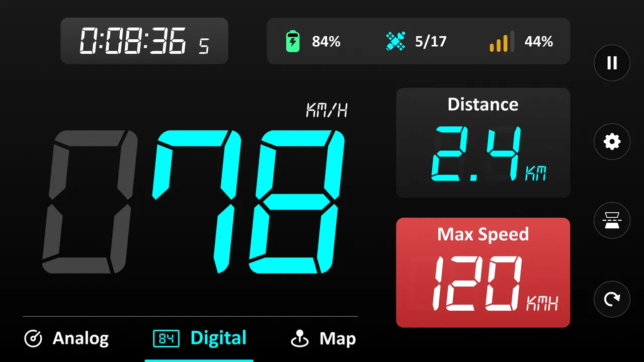
The central capability is simple: the app uses your phone’s GPS position to show how fast you are moving and how far you have traveled. That sounds basic, but it changes the way the phone is useful during a journey. A map app normally asks you to enter a destination and follow a route. Here, I can open the app simply to observe the trip itself.
You May Also Like

 AccuWeather: Weather Radar
AccuWeather Review: A Quick, Clear Forecast for Everyday Decisions
For everyday plans, the best forecast is the one you can understand quickly. AccuWeather makes rain timing, radar, and local conditions easy to act on, with a few trade-offs.

 Hill Climb Racing
Why Hill Climb Racing Still Turns Crashes Into One More Run
A tiny car, a bumpy hill and one more upgrade: Hill Climb Racing keeps resurfacing because its simple chaos makes every near-miss feel personal.

 AliExpress - Shopping App
AliExpress Makes Global Shopping Feel Personal, but Shoppers Bear the Risk
AliExpress turns a global marketplace into a pocket-sized discovery engine. Its reach is useful, its shopping loop compelling, and its trade-offs easy to miss.

 Lords Mobile: Kingdom Wars
Lords Mobile Is a Kingdom-Building Routine, Not a Quick Match
A case-by-case verdict on the building, battles, device demands, and social commitments that make Lords Mobile rewarding for some players and exhausting for others.

 PDF Scanner app - TapScanner
TapScanner Makes Paperwork Easier to Capture, Check, and Share
TapScanner makes scanning with a phone feel less like a rescue operation and more like a dependable step in getting work done. Its capture tools are useful, though not flawless.

 Block Blast!
 Shows How Much a Puzzle Game Can Leave Out
A quiet grid game shows why puzzle players increasingly value instant clarity, repeatable skill and low-pressure play—and where the genre still needs to catch up.
More From Our News Desk
View All News


That distinction matters on familiar roads. If I already know where I am going, a full navigation app can feel unnecessarily busy, with route lines, place suggestions, traffic information, and other controls competing for attention. A dedicated GPS speedometer gives the journey a cleaner purpose. I can glance at the current speed, check the accumulated distance, and use the location and time information as a compact record of movement.
I would not treat it as a replacement for a standard navigation service. It does not occupy the same role as a map that helps me choose a route or recover when I miss a turn. Its strength is measurement, not guidance. That makes it especially relevant for people who want a visible instrument panel while traveling, rather than another map with a speed readout added as a secondary feature.
The app has attracted a substantial audience, with over ten million installs, a 4.0 average from around two hundred thousand ratings, and roughly three thousand six hundred written reviews. Those figures suggest that the straightforward idea has broad appeal, although they do not remove the need to judge whether a speed-and-distance display fits your own routine.
Why the speed reading is more useful than it first appears
Speed is not only a number for drivers checking a limit. It can help me understand the character of a trip. On a bicycle, a changing speed display makes hills, headwinds, and stops easier to notice. During a walk, the reading can show whether I am moving steadily or pausing more often than I realized. In a vehicle, it provides a dedicated visual reference when the built-in display is difficult to read or when I am riding as a passenger and want to observe the journey.
The distance counter adds a second layer. A short outing can feel longer or shorter than it really is, especially when it includes several stops. Watching distance build over the trip gives a more concrete sense of progress. For repeated journeys, I can also use the figure as a rough comparison between routes, provided I remember that GPS readings are estimates rather than laboratory measurements.
The most important practical lesson is to use the app as an awareness tool, not as an unquestionable instrument. GPS reception can vary between open roads, city streets, covered areas, and places where tall buildings interrupt the signal. A displayed speed may take a moment to settle after movement begins, and distance can be affected when the location signal jumps. That is not a flaw unique to this app, but it is an important limit when interpreting what I see.
What using it during a real trip feels like
In practice, the workflow is uncomplicated. I open the app before setting off, give the phone a clear view of the sky when possible, and let the location reading become useful before relying on it. Once moving, the screen works best as a quick-glance panel. I do not need to interact with it constantly; the value comes from checking the live information at sensible moments.
For a driver, that means mounting the phone securely and looking only when it is safe. The app should never encourage handling the phone while the vehicle is moving. If the car already has a reliable speed display, the app is more useful as a secondary trip monitor than as a reason to ignore the dashboard. For a passenger, it can be a convenient way to watch the journey without changing the driver’s setup.
For cycling, placement becomes more important. A phone mounted where the screen is visible can make the speed reading easy to consult, but vibration, glare, and battery use may affect the experience. I would start a ride with the phone charged and avoid treating the display as the only information source. The app is best when it supplements sensible riding habits, not when it becomes something I stare at continuously.
Walking is the least demanding scenario. I can keep the phone in hand or check it occasionally, and the distance figure becomes a simple way to understand an outing. This is also where the app’s narrow design feels comfortable: I am not asking it to direct me through unfamiliar streets, only to show how far I have gone and how long the activity has lasted.
Location and time give the readings useful context
Speed by itself can be hard to interpret. The location and time information help place that number inside the journey. If I stop at a viewpoint, pause for a break, or take a slower side road, the trip makes more sense when I consider the whole movement rather than a single peak speed. The display therefore works as a small travel instrument, not merely a digital speed sign.
One useful habit is to check the reading after a signal change instead of reacting immediately to a sudden jump. When leaving a tunnel, a parking structure, or a dense urban area, the phone may need a moment to establish a stable position. I found that treating the first few moments as a settling period leads to more sensible conclusions about both speed and distance.
Another practical habit is to begin measuring at a consistent point. If I start one trip while still walking toward a vehicle and another only after joining the road, the distance comparisons will not mean much. For repeat journeys, choosing the same start and finish points makes the app more useful as a personal reference, even though it should not be treated as a professional surveying tool.
A realistic everyday scenario: checking a weekend route
Imagine taking a familiar weekend drive to a market outside town. I do not need turn-by-turn directions because I know the road, but I am curious whether a quieter route adds much distance. I place the phone safely, start the app before leaving, and use the speed display as a separate reference while the car’s own controls remain primary.
At the destination, the distance reading gives me a quick sense of the outward trip. On the way home, I take the alternative road and compare the result after reaching the same general starting area. The app does not tell me which route is better, and it cannot explain whether extra distance was worth the scenery or lower traffic. What it does provide is a simple measurement that supports my own judgment.
The same pattern works for a cycling loop. I can start at the park entrance, ride without needing navigation, and check the distance at the end. If I repeat the loop later, the figures help me see whether I extended the route. The key is that the app stays in the background of the activity. It supplies context without demanding that I plan the entire experience around it.
Where it fits beside ordinary navigation alternatives
A conventional map app is better when I need directions, searchable destinations, route alternatives, or help in an unfamiliar area. It usually offers a broader picture of the journey. If my priority is arriving somewhere efficiently, I would choose that kind of tool first.
A vehicle’s built-in speedometer is better for the essential driving task because it is already positioned for the driver and designed as part of the car’s controls. I would not install this app expecting it to improve on a dependable dashboard. Its advantage is flexibility: it can travel with me between vehicles, work for activities outside driving, and show trip-oriented information in one place.
A fitness-focused tracker may be better for structured exercise, training history, or detailed activity analysis. GPS Speedometer - Odometer App makes more sense when I want a lightweight readout without turning a casual walk or ride into a complete fitness project. That simplicity is appealing, but it also means I should not expect the broader coaching and analysis associated with specialized fitness products.
There is also a useful difference between a dedicated display and a navigation screen with many overlays. When I am already familiar with the route, less information can be an advantage. I can focus on speed and distance instead of sorting through map controls. On the other hand, if I need to understand the road ahead, the stripped-down view becomes a limitation rather than a benefit.
Small workflow choices that improve the experience
First, I would test the app in an open area before depending on it for a trip. This makes it easier to recognize how quickly the location reading becomes stable on my phone and avoids mistaking an initial fluctuation for a real change in speed. It is a simple preparation step, but it prevents unnecessary concern during the journey.
Second, I would decide in advance what question the trip is meant to answer. Am I checking the length of a walking route, observing cycling pace, or comparing two familiar drives? A clear purpose makes the readings more useful. Without one, it is easy to keep watching numbers that do not lead to any practical decision.
Third, I would use consistent start and stop points when comparing outings. GPS distance is most helpful for broad personal comparisons, not for claiming exact precision. Starting the counter at the same landmark and ending it at the same destination reduces one source of inconsistency and makes the result easier to interpret.
Finally, I would keep the phone’s role secondary during driving. A stable mount and safe glances matter more than seeing every change in the display. If the screen is hard to read because of sunlight or placement, the correct response is to adjust the setup while stationary, not to interact with the phone in motion.
The trade-offs I would consider before installing it
The first trade-off is scope. The app’s focused design is also its boundary. It can show movement-related information, but it is not the right choice for someone who expects a complete travel assistant. If you need route planning, live road decisions, or destination discovery, a conventional navigation app will serve you better.
The second is dependence on GPS conditions. The app cannot make a weak signal accurate through software alone. Urban canyons, covered roads, indoor areas, and other obstructions can affect the readings. For casual awareness, that is acceptable. For official records, billing, precise route surveying, or any situation where a small error matters, I would choose equipment and software designed for that specific standard.
The third concerns attention. A live number can be oddly tempting to watch, particularly when cycling or driving. The app is useful only if I treat it as something to consult briefly. Anyone who finds a changing display distracting should skip using it in motion and check results after stopping instead.
There is also the question of cost structure. The app is free to install, while in-app purchases range from $1.99 to $49.99 per item. That does not automatically make it poor value, but I would review any purchase screen carefully and decide whether the basic experience already meets my needs. For someone wanting only a simple speed and distance display, paying for extras may not be necessary.
The Everyone age rating makes it broadly approachable, but suitability still depends on supervision and context. A younger user might enjoy watching a family road trip or measuring a walk, yet safe phone handling remains the adult’s responsibility during vehicle travel. The age label describes accessibility, not permission to use the phone carelessly.
Who should skip it
I would skip this app if my main goal is navigation in unfamiliar places. The focused dashboard will not replace the reassurance of a route line, spoken directions, and destination search. I would also skip it for professional measurement, where dedicated instruments and documented accuracy are more appropriate.
It may not suit someone who already has a clear, readable speed display and never wants trip distance or location context. In that case, installing another screen adds little. Likewise, users who want detailed exercise records may find a fitness tracker more suitable, because this app’s appeal is its immediate, uncomplicated view rather than a complete training system.
Who gets the most from this focused tool
The strongest audience is people who regularly travel familiar routes and want an independent view of movement. Drivers can use it as a portable secondary display, especially when switching between vehicles. Cyclists and walkers can use it to understand the distance and pace of casual outings without committing to a more elaborate tracking workflow.
It is also useful for curious travelers. On a scenic drive, I might care less about arriving quickly than about understanding how much ground the route covers. During a long walk in a new park, the distance reading can help me decide whether to turn back. These are modest needs, but the app handles them with less clutter than a full navigation platform.
Tech 4 All Apps has kept the product’s identity clear: a free measurement-oriented navigation app rather than an all-purpose travel suite. That clarity is reflected in the way I would recommend it. I would tell a friend to try it when they want a portable GPS speedometer and odometer-style display, not when they want a map to solve every travel problem.
My final view is positive but specific. GPS Speedometer - Odometer App is worthwhile because it makes speed, distance, location, and time easy to observe during ordinary journeys. Its best quality is restraint: it gives me a compact instrument panel instead of overwhelming me with navigation features I may not need. The trade-off is equally clear: GPS behavior varies, the app is not professional measuring equipment, and it cannot guide me like a full map service.
If that boundary matches your needs, the free entry point makes it easy to test on a familiar walk or drive. Start in an open area, compare readings sensibly, and use it as a companion rather than an authority. For me, that is where GPS Speedometer - Odometer App earns its place: not as a replacement for the usual navigation tools, but as a focused way to understand the movement of a trip.
FAQs for GPS Speedometer - Odometer App
01What is GPS Speedometer - Odometer, and how does it work?
GPS Speedometer - Odometer is a mobile app that uses your phone’s GPS to measure travel speed, distance, and trip duration. After granting location permission and starting a journey, it displays speed in real time and records odometer-style distance information. It is useful for driving, cycling, walking, jogging, or other outdoor activities, although its readings depend on GPS signal quality.
02Is GPS Speedometer - Odometer accurate enough for driving?
The app can provide a helpful estimate of your current speed, especially when the phone has a clear view of the sky and a stable GPS connection. However, it should not be treated as a replacement for your vehicle’s certified speedometer or official navigation equipment. Accuracy may decrease near tall buildings, tunnels, indoors, under heavy tree cover, or when the device is experiencing a weak or interrupted signal.
03Does the app work without an internet connection?
GPS Speedometer - Odometer may continue measuring speed and distance without mobile data because standard GPS positioning can work offline. Nevertheless, the first location fix may take longer, and some features—such as advertisements, online maps, cloud synchronization, or location-related services—could require an internet connection. It is best to test the app before starting a trip in an area with limited coverage.
04What permissions does GPS Speedometer - Odometer require?
The main permission is access to your device’s location, which is necessary for calculating speed, distance, and movement. Depending on the version and your phone settings, the app may also request permission to run in the background or remain active while the screen is locked. Review each request carefully, allow only what is needed, and disable background access if you do not want continuous location tracking.
05Can GPS Speedometer - Odometer track trips and save odometer information?
The app is designed to help monitor journeys by showing distance traveled and related trip data while you are moving. Available recording and history options can vary by version, device, and operating system, so users should check the in-app controls before relying on it for long-term records. Keep the phone charged, secure it in a stable position, and avoid interacting with the app while driving.
Pros
- Shows current speed clearly in both km/h and mph.
- Tracks trip distance and total mileage for everyday journeys.
- Works with GPS without requiring a mobile data connection.
- Simple interface that is easy to read while driving.
- Useful for checking vehicle speedometer accuracy on road trips.
Cons
- GPS accuracy may drop in tunnels
- garages
- or areas with weak signal.
- Continuous GPS use can noticeably reduce battery life.
- Background tracking may require extra permission settings on some phones.
- Some features may be limited by advertisements or in-app purchases.
- Readings can take a moment to stabilize after starting the app.

GPS Speedometer - Odometer App
Gallery